
As a Classics student and an Oregon Trail buff, this is beyond cool.
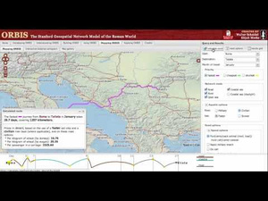
Ever wondered how long it would take to travel from Rome to Constantinople at the peak of the Roman Empire? Or from Luna to Larissa? Or Parma to Thessalonica? This map of the Roman World created at Stanford University is awesomely realistic — all the ancient transportation lines on it actually existed 2,000 years ago.
Tell us, would you like to travel to Rome by road, river or open sea? Would you stick to the coasts or set a course through the mainland? During which month would you journey? Would you opt for the fastest route (bearing in mind that the shortest course does not always translate to the quickest passage) or the cheapest? Speaking of expenses, how much would this journey cost you, anyway? (Please give your answer in denarii.)
Confused? Overwhelmed? Fear not — ORBIS is here to help you plan your trip.
This interactive travel map of the Roman Empire is like Oregon Trail meets Civilization.